Ground Truth & Data Acquisition
Provides positioning ground truth, vehicle data and synchronized image acquisition for ADAS testing, supporting analysis and result review.
Ground Truth & Data Acquisition Capability
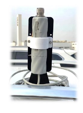
The ground truth system uses GNSS positioning as the measurement basis, combined with IMU inertial sensors and motion algorithms to output vehicle position, speed and distance.
The data acquisition system supports CAN data, images and dashboard indicator signals, helping test teams record and analyze test processes synchronously.
- GNSS/RTK positioning ground truth
- Synchronized CAN + image acquisition
- Dashboard indicator acquisition
- Data storage and playback
Key Specifications
| Positioning | GNSS/RTK + IMU |
|---|---|
| Data output | Integrated navigation and ranging data |
| Acquisition interfaces | CAN / image / sound |
| Image acquisition | Multi-camera support |
| Communication | In-vehicle wireless communication |
| Applications | AEB / LKA / regulatory testing |
| Test site information | Multiple test sites; please contact us |
Applications
- AEB distance and speed measurement
- LKA testing
- Multi-vehicle synchronized data acquisition
- Test data review and analysis
System Modules
Modules can be combined for different test objectives; the final configuration depends on project requirements.
GNSS Positioning Ground Truth System
High-precision position, speed and distance measurement.
Vehicle Ranging Unit
Relative distance and speed measurement between vehicles.
CAN + Image Acquisition
Synchronized vehicle bus and multi-channel image data.
Dashboard Indicator Acquisition
Industrial camera and image recognition for warning signals.
Sound and Data Storage
Sound frequency detection, data recording and playback.
Looking for a complete solution?
Tell us about your test scenarios and targets, and we will provide further details based on your requirements.